Today, the Nebraska Department of Environmental Quality issued the statement below, saying they’ve given TransCanada an official map of the Sandhills. TransCanada promised during the Pipeline Special Session to reroute their Keystone XL pipeline around Nebraska’s sensitive Sandhills. We have not yet heard TransCanada’s reaction to the new map, but there are some visible differences from the map we were told they were previously using.
In reaction to the news, Jane Kleeb said, “Bold Nebraska trusts NDEQ to conduct a thorough review of the proposed new route and look out for our state’s precious resources. We trust TransCanada to do what’s best for their bottom line, not what’s best for Nebraska. That is why we’ll continue to ask citizens and landowners to participate in the review process.”
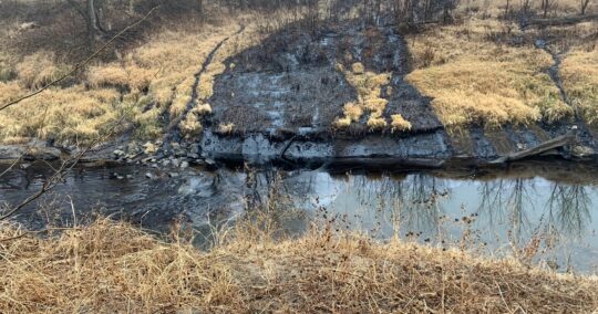
Bruce Boettcher, a rancher from the Sandhills added, “So, the Nebraska Sandhills shrunk? No wonder why the NDEQ did not want to meet with Nebraska citizens who were concerned about land formations and soil types that are similar to the Sandhills. I question the thoroughness of this review, especially since there is a spring fed creek and sandy soil at the entrance point.”
His daughter, Amy Schaffer expressed concern that the designated Sandhills were too small saying, “Can it really be this black and white? If you travel the regions on this map that are not declared as being in the Sandhills the soil types and topography will tell you otherwise. Given the vulnerability of the Sandhills wouldn’t it make more sense to declare the Sandhills in excess rather than minimizing them? This is disappointing; I expected much more from the NDEQ.”
Press Release from NDEQ:
Maps Identify Sandhills Regions to be Avoided in Alternative Pipeline Route
The Nebraska Department of Environmental Quality today announced the areas that it considers to be Nebraska Sandhills, based on an analysis of a variety of existing data. This information will be conveyed to TransCanada for their reference as the company develops a proposed new route for the Nebraska portion of the Keystone XL pipeline.
NDEQ Director Mike Linder said this was an important step resulting from legislation which was passed in November relating to the development of an alternative route that avoids the Nebraska Sandhills.
“Obviously, the applicant cannot propose the route without knowing the area to be avoided,” Linder said. “NDEQ has been reviewing available information and has selected a map of ecoregions which was finalized in 2001 as best depicting the Sandhills region.”
This map, titled “Ecoregions of Nebraska and Kansas” was a multi-year project involving numerous state and federal agencies, including: the U.S. Environmental Protection Agency, NDEQ, the U.S. Geological Survey, Nebraska Game and Parks Commission, and the U.S. Forest Service.
Attached is a map from NDEQ that shows an outline of the Sandhills region in Nebraska. The more comprehensive map that delineates a variety of ecoregions in both Nebraska and Kansas can be found on EPA’s web site, at: ftp://ftp.epa.gov/wed/ecoregions/ks/ksne_eco_pg.pdf
This information is being conveyed to TransCanada today. TransCanada will consider this information as it develops an alternative route for the pipeline. When TransCanada submits alternative route information, NDEQ will move forward in the development of a Supplemental Environmental Impact Statement, which will consider a variety of potential environmental impacts.
NDEQ will provide opportunities for public participation during the process. Early in the process, the agency will conduct a series of information sessions to discuss what is being proposed and solicit public input. Later, when a draft Supplemental Environmental Impact Statement is developed, a formal public comment period will be held.
Information will continue to be updated on the agency web site. Go to www.deq.state.ne.us and select “NDEQ’s Role in Pipeline Review” or follow the direct URL to: www.deq.state.ne.us/gen.nsf/Pages/Pipeline.
Questions and comments can be sent to a new NDEQ e-mail address: NDEQ.SEISpubliccomment@Nebraska.gov. An NDEQ pipeline telephone comment line has also been established at 1 (800) 295-8912.
Background on NDEQ’s New Responsibilities
On November 22, 2011, Gov. Dave Heineman signed LB4 into law, which provides new responsibilities to NDEQ relating to supplemental environmental impact statements involving oil pipelines. The first application of the new law is the development of a supplemental environmental impact statement for the proposed TransCanada Keystone XL pipeline.
The legislation assigns NDEQ to work with the U.S. Department of State throughout the review. Negotiations continue with the U.S. Department of State to finalize a Memorandum of Understanding detailing how NDEQ’s environmental review process will fit into the federal review process.
An additional map that the NDEQ also unveiled yesterday was one that shows the various ecoregions of our state, although there is no agreement by TransCanada to avoid the Ogallala Aquifer nor other senstive areas other than the Sandhills. You can view the ecoregion map here.